USA Information
5 States of USA
Mississippi
Mississippi
is a state in the Southern United States, with part of its southern
border formed by the Gulf of Mexico. Its western border is formed by the Mississippi River.
The state has a population of
approximately 3 million. It is the 32nd most
extensive and the 32nd most
populous of the 50 United
States. Located in the center of the
state, Jackson is the state capital and largest city, with a
population of approximately 175,000 people.
The state is heavily forested
outside of the Mississippi
Delta area, between the Mississippi
and Yazoo rivers. Before the American Civil War, most development in the state was along
riverfronts, where slaves worked on cotton plantations. After the war, the
bottomlands to the interior were cleared, mostly by freedmen. By the end of the 19th century, African Americans made up two-thirds of the Delta's property owners,
but timber and railroad companies acquired much of the land after a financial
crisis.
The state's name is derived
from the Mississippi River, which flows along its western boundary. Settlers
named it after the Ojibwe word misi-ziibi
("Great River").
Mississippi is bordered to the north by Tennessee,
to the east by Alabama, to the south by Louisiana and a narrow coast on the
Gulf of Mexico; and to the west, across the Mississippi River, by Louisiana and
Arkansas.
In addition to its namesake,
major rivers in Mississippi include the Big Black
River, the Pearl River, the Yazoo River, the Pascagoula River, and the Tombigbee River. Major lakes include Ross
Barnett Reservoir, Arkabutla Lake, Sardis Lake, and Grenada Lake with the largest lake being Sardis Lake.
Mississippi is entirely
composed of lowlands, the highest point being Woodall Mountain, in the foothills of the Cumberland
Mountains, 807 feet (246 m) above sea level. The lowest point is sea level at the Gulf coast. The state's mean elevation is 300 feet (91 m)
above sea level.
Utah
First
of all, where does the name ‘Utah’ come from? Utah comes from the Apache word
‘yuttahih’ wich means ‘people of the mountains’.
Utah
was the 45th to be accepted as a state of the country.
It’s
situated at the Wester United States, next to Wyoming, wich we will talk about
later, Colorado, Nevada, Arizona and Idaho.
Maybe
the most characteristic fact about Utah is the uncountable farms it has. They
take up almost 1/5 part of the total area.
Big
part of its economy comes from farmers and people who work in lands.
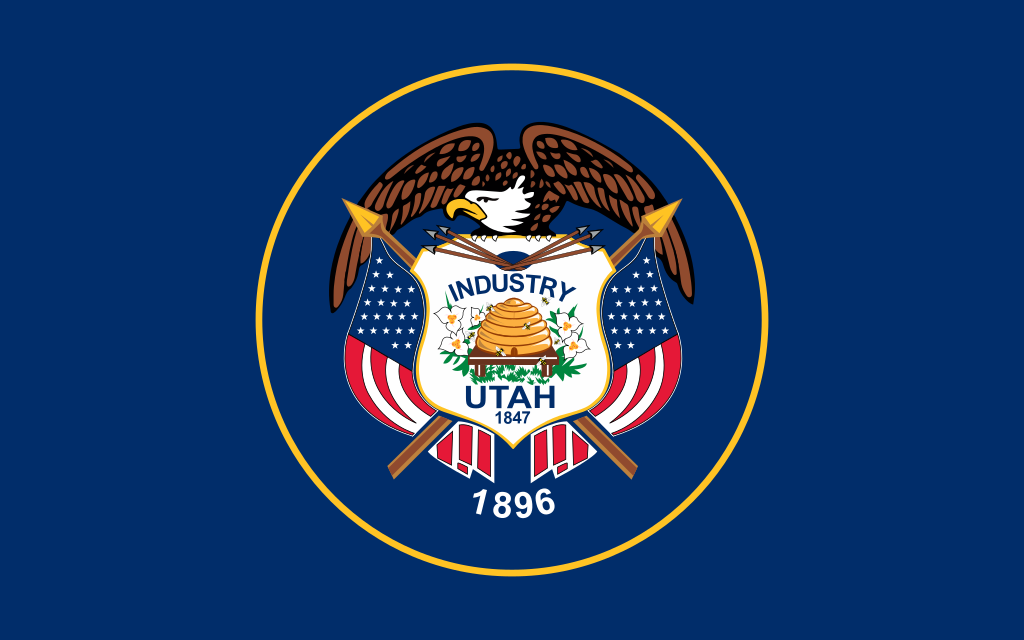
The flag of this State contains many significant things. First of all, the beehive and the sego lily, the flower of Utah, wich both represent hard work. Next, the eagle on top, that represents protection in peace and war (te eagle is the national bird of USA).
Finally, the two dates that appear in the flag mean two different things: 1847, the year that Mormon Pioneers entered the Salt Lake City Valley, and 1896, the year when Utah was accepted as a state of USA.
Ohio

Red Carnation: It is the official flower of Ohio. The red carnation was chosen to honor President William McKinley (an Ohioan) who was assassinated in 1901. President McKinley liked to wear red carnations on the lapel of his jacket.
State Emblem: In the modern version, the Scioto river flows between cultivated fields and Mount Logan. A rising sun with 13 rays symbolize the original thirteen colonies. A bunch of corn stands in the foreground as a symbol of agriculture.
 Ohio is the 34th
largest by area, the 7th most populated, and the 10th
most densely populated of the country: 11,614,373 inhabitants (2016). The
state's capital and largest city is Columbus.
Ohio is the 34th
largest by area, the 7th most populated, and the 10th
most densely populated of the country: 11,614,373 inhabitants (2016). The
state's capital and largest city is Columbus.
 California is considered a global trendsetter in popular culture,
innovation, and politics. It is the origin of the film industry, the hippie counterculture, the Internet, and the personal computer, among others.
California is considered a global trendsetter in popular culture,
innovation, and politics. It is the origin of the film industry, the hippie counterculture, the Internet, and the personal computer, among others.
 Weather varies across the U.S., as well as in Alaska and Hawaii:
The flag of this State contains many significant things. First of all, the beehive and the sego lily, the flower of Utah, wich both represent hard work. Next, the eagle on top, that represents protection in peace and war (te eagle is the national bird of USA).
Finally, the two dates that appear in the flag mean two different things: 1847, the year that Mormon Pioneers entered the Salt Lake City Valley, and 1896, the year when Utah was accepted as a state of USA.
Ohio
The state
takes its name from the Ohio River. The name was originated from the Seneca
language word ohiːyo', meaning "great river".

State flag: Ohio's state flag was adopted in
1902. The Ohio burgee, as the swallowtail design is properly called, was
designed by John Eisenmann. The large blue triangle represents Ohio's hills and
valleys, and the stripes represent roads and waterways. The 13 stars the
original states of the union; the 4 stars added to the peak of the triangle
symbolize that Ohio was the 17th state admitted to the union. The
white circle with its red center represents the "O" in Ohio and
Ohio's famous nickname, "The Buckeye State”
Constitution of Ohio: The Ohio Constitution is the basic
governing document of the State of Ohio, which in 1803 became the 17th state to
join the United States of America. Ohio has had three constitutions since
statehood was granted. The current one was written in 1912.
Ohio was created from the easternmost portion
of the Northwest Territory. In 1787, the Congress of the Confederation of the
United States passed the Northwest Ordinance, establishing a territorial
government. The Ordinance prohibited slavery and provided for freedom of
worship, the right of habeas corpus and trial by jury, and the right to make
bail except for capital offenses. Ohio courts have noted that the Northwest
Ordinance
Red Carnation: It is the official flower of Ohio. The red carnation was chosen to honor President William McKinley (an Ohioan) who was assassinated in 1901. President McKinley liked to wear red carnations on the lapel of his jacket.
State Emblem: In the modern version, the Scioto river flows between cultivated fields and Mount Logan. A rising sun with 13 rays symbolize the original thirteen colonies. A bunch of corn stands in the foreground as a symbol of agriculture.
Standing next to the corn, there is a bundle of
17 arrows representing Ohio's Native Americans and symbolizing Ohio as the 17th
state to enter the Union.
 Ohio is the 34th
largest by area, the 7th most populated, and the 10th
most densely populated of the country: 11,614,373 inhabitants (2016). The
state's capital and largest city is Columbus.
Ohio is the 34th
largest by area, the 7th most populated, and the 10th
most densely populated of the country: 11,614,373 inhabitants (2016). The
state's capital and largest city is Columbus.
It occupies 116,096 km2, 355 km width and 355km
length.
There’s 275km between Lucas and Adams, and
203km between Columbus and Van Wert.
California
California is the most populous
state in the U.S.A and the third most extensive by area. Sacramento is the
state capital. Los Angeles is California's most populous city, and the country's second-most populous, after New York City. If it were a
country, California would be the 5th largest economy in the world, and the 36th most populous.
 California is considered a global trendsetter in popular culture,
innovation, and politics. It is the origin of the film industry, the hippie counterculture, the Internet, and the personal computer, among others.
California is considered a global trendsetter in popular culture,
innovation, and politics. It is the origin of the film industry, the hippie counterculture, the Internet, and the personal computer, among others.
California is bordered by Oregon
to the north, Nevada and Arizona to the east, and the Mexican state of Baja California to the
south. The state's diverse geography ranges from the Pacific Coast in
the west to the Sierra Nevada mountain range in the east, and
from the redwood–Douglas fir forests in the northwest to the Mojave Desert in the
southeast. The Central Valley, a major agricultural area, dominates the
state's center. Though California is well-known for its warm Mediterranean climate, the large size of the state results in climates
that vary from moist temperate
rainforest in the north to arid desert in the interior, as well as snowy alpine in the mountains.
General Information about USA
CLIMATE OF
THE U.S.A.
 Weather varies across the U.S., as well as in Alaska and Hawaii:
In general,
summers are hot and humid in the plains and southern states, while the
southwest is very hot and quite dry.
Endless
summers are southern California and Florida trademarks, while in the Pacific Northwest
and New England states, summers are warm with cool mornings.
Winters in
the southern states are mild, while in the north, northeast, plains states, and
in the western mountains, conditions are often quite cold with heavy snow and sub-freezing
temperatures.
State-wide averages of annual
rainfall plus snowfall range from a high of 63.7 inches (1618 millimeters) in
Hawaii to a low of 9.5 inches (241 millimeters) in Nevada.
For the entire United States, excluding Hawaii
and Alaska, the average amount of moisture falling as rain and snow is 30.21
inches (767 millimeters).
ECONOMY OF
THE U.S.A.
The United
States of America has the world's largest national economy. It makes up roughly
17 to 22 percent of the world's gross domestic product (GDP). The currency of
the United States, the dollar, is the most widely used currency in
international trade.
The three sectors of the economy
Primary sector includes agriculture, farming,
fishing, forestry, mining. As of the 2007 census of agriculture, there were 2.2
million farms, covering an area of 3,730,000 km2. It is particularly
concentrated in the Great Plains, a vast expanse of flat, arable land in the
center of the country.
In fact, California ranks first in
the United States for agricultural cash receipts followed by Iowa, Texas,
Nebraska and Illinois.
Ten states generate more than $10 billion in agricultural
cash receipts: California, Texas,
Nebraska, Illinois, Minnesota, Kansas, Indiana, Wisconsin and North Carolina.
Primary exports include wheat, corn,
vegetables, cotton, beef, pork, dairy products, fish and forest products.
Secondary sector is defined as the industrial sector
of an economy dominated by the manufacture of finished products. Enormous
amounts of energy are consumed to carry this process out. Industries include
the automobile industry, the chemical industry, consumer electronics,
industrial equipment, steel production, the tobacco industry, aerospace
manufacturing, textile industry and telecommunications.
Among the fifty states, California
emerges in the study as the leader in most industry subsectors, that includes
Motion Picture and Videos, Management, Scientific… What’s more, Pennsylvania
leads the industry of Individual and Family Health Services and Legal Services.
The tertiary sector provides services to the general
population. Activities associated with this sector include, transportation and
distribution, entertainment, restaurants, clerical services, media, tourism...
It includes the quaternary sector which is
defined as the use of modern technology in research and development to train
and provide information to other industries
The United States of America has over 250,000 rivers. The longest river in the USA is the Missouri River; tributary of the Mississippi River, which is 2,540 miles long. But the biggest in terms of water volume is the deeper Mississippi River.

Rivers in USA
The United States of America has over 250,000 rivers. The longest river in the USA is the Missouri River; tributary of the Mississippi River, which is 2,540 miles long. But the biggest in terms of water volume is the deeper Mississippi River.
The longest
un-dammed river in the contiguous USA is the Yellowstone River; it is 692 miles
long.
Rivers provide drinking water, irrigation water, transportation, electrical power, drainage, food, and recreation. Rivers also erode land and carry it to the sea. This kind of erosion can even form canyons, like the Grand Canyon, and waterfalls, like Niagara Falls.
While some of the USA rivers and lakes serve as vital waterways for inland navigation others are useful sources of irrigation and power generation.

- Columbia River
- Snake River
- Missuri River
- Rio Grande
- Colorado River
- Mississippi River
- Potomac River
- Tennessee River
Columbia River is situated in the South West of
Canada and flows in north-south-west direction, and flows into the Pacific
Ocean.
The
river takes the name of Caumbia Rediviva, the name of the first boat that went
on it.
Is the
6th longest river of the USA, with a length of 2044 km and goes through
the states of Washington DC and Oregon. Is the widest river in the USA.
This
river has been used for many human interests since its discover. Dams have been
constructed for avoiding floods and for creating energy.
Colorado River is situated in the South of the United
States. Crosses states of Colorado, Utah, Arizona, Nevada, California, Low
California and Sonora, in Mexico.
This
river is 2333km long, situated above the Columia River, in 5th place
of longest rivers in USA. You can find the beginning of the river in a little
village called La Poudre Pass, at 3.100m above sea level, north Colorado.
This river
floods into some lakes and then it keeps it going. For example, at the beginning
of it, Colorado River flows into a lake called Gran Lago, in Colorado. Then,
this lake keeps flowing down till it crosses the Grand Canyon, and then it flows
really close to Las Vegas.
Mississippi River is a 3734km river that flows through
10 different states (Minnesota, Wisconsin, Iowa, Musuri, Illinois, Kentucky,
Tennessee, Arkansas, Mississippi and Luisiana).
The
beginning of this river is situated at Lake Itasca, a small glacial lake in the
North East of the United States, near the city of Mississippi.
From a
long time ago this river has been a really important way for navigation. The
American natives used to call it a long time ago “Meschacebé”, that used to
mean “father of the water”.
Nowadays,
Mississippi river is a crucial component of the USS economy.
Rio Grande
Is the 4th
longest river of the United States. It’s situated on the South of USA and North
of Mexico. It’s beginning is in Central Colorado and flows to the Goulf of
Mexico.
During the late-1830s and early-1840s,
the river marked the disputed border between Mexico and the Republic of Texas;
Mexico marked the border at the Nueces River. The disagreement provided
part of the rationale for the US invasion of Mexico in 1846, after
Texas had been admitted as a new state. Since 1848, the Rio Grande has marked
the space between Mexico and the United States from the twin cities of El
Paso, Texas, and Ciudad Juárez, Chihuahua, to the Gulf of Mexico.
In 1899, after a gradual change to the
river position, a channel was dug for flood control which moved the river,
creating what was called Cordova Island, which became the center of the Chamizal
dispute. Resolving the dispute took many years and almost resulted in the
assassination of the American and Mexican presidents.
In 1997, the US designated the Rio Grande as one of the American
Heritage Rivers. Two portions of the Rio Grande are designated National
Wild and Scenic Rivers System, one in northern New Mexico and the other in
Texas, at Big Bend National Park.

Comentarios
Publicar un comentario